
When you visualize a file in AO, the options you're asked for depend on the kind of file. This article lists them. For which files AO can visualize and how to prepare them, see Supported file types and format requirements.
Every visualization also has a Name, which starts as the file name and must be different from the other visualizations in the project, and a Coordinate Reference System (CRS). AO fills the CRS in from the file, or from the project's default, when it can; otherwise you choose it. See Vertical and Horizontal Datum.
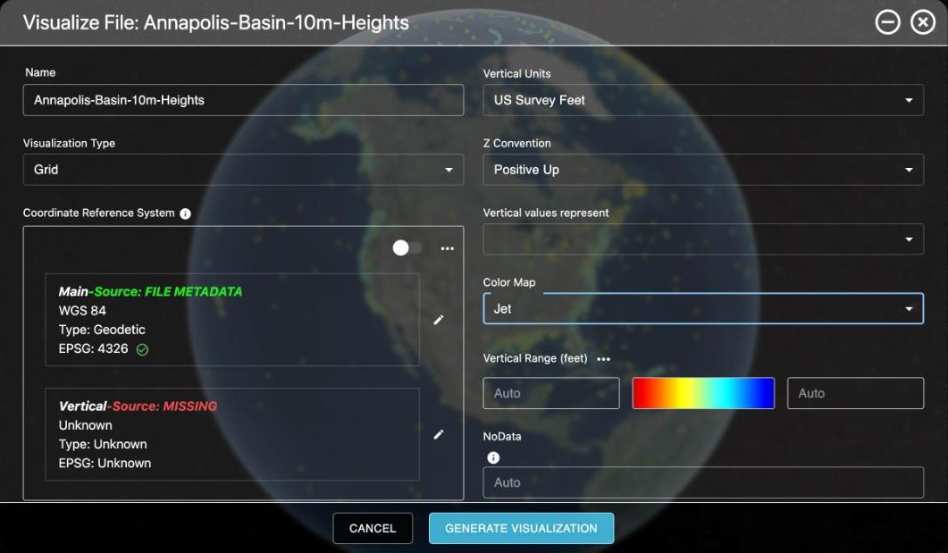
Images and grids (GeoTIFF, BAG)
| Option | Choices | Notes |
|---|---|---|
| Visualization Type | Imagery (default) or Grid | Choose Grid for elevation or depth: a single-band GeoTIFF or a BAG file. A grid becomes its own 3D terrain. |
| Data Type (Imagery) | Side Scan (default), Synthetic Aperture Sonar, Magnetometer, Other | |
| Z Convention (Grid) | Positive Up (default) or Positive Down | Whether values are heights or depths. Vertical Units (Meters or US Survey Feet) shows when the vertical CRS doesn't give units, such as before you choose one, or with a Custom Vertical Offset when no vertical CRS was chosen first; it starts at your display units. Vertical values represent (Height or Depth) shows when the vertical CRS doesn't say which, but not with a Custom Vertical Offset. |
| Color Map | Jet, Greyscale, Gold or Other | Applies to grids and to single-band 32-bit floating-point images; other images keep their own colors. Other keeps the colors already in the file. If the file has its own colors, AO starts with those; otherwise grids start with Jet, side scan with Gold and other imagery with Greyscale. |
| Vertical Range or Color Range | Minimum and maximum | Optional. You can set it for grids; for imagery, Color Range shows but can't be changed. Vertical Range is in the file's vertical units, such as (m) or (feet). For bathymetry, Vertical Range starts filled with the project's elevation range, if the project has one, and is labeled Source: PROJECT DEFAULT; clear or change it for this file. With no range, AO spreads the color map between the file's lowest and highest values. Set a range to ignore outliers or to match neighboring files. |
| NoData | A value | Single-band files only. AO normally reads it from the file; change it only if empty cells show up colored. |
Point clouds (LAS, LAZ, XYZ, CSV, TXT, ASC)
| Option | Choices | Notes |
|---|---|---|
| Data Type | Bathymetry, Side Scan, Synthetic Aperture Sonar, Magnetometer, Other | |
| Z Convention, Vertical Units | Positive Up or Positive Down; Meters or US Survey Feet | For every Data Type, unless the CRS is 3D or compound. Vertical Units shows only when the CRS doesn't give them. |
| Color Map | Jet or Other | Points that carry their own colors keep them; other points are colored with Jet, whichever you choose. |
| Vertical Range or Color Range | Minimum and maximum | Optional, as for grids. You can set it only with Data Type Bathymetry; otherwise Color Range shows but can't be changed. |
Vector files (SHP, KML, KMZ, GeoJSON)
| Option | Choices | Notes |
|---|---|---|
| Vector Color | Any color | White by default. |
| CRS (SHP only) | An EPSG code | Asked for only when the shapefile has no .prj file beside it. KML, KMZ and GeoJSON are always read as WGS 84. |
HYPACK grids (MTX)
| Option | Choices | Notes |
|---|---|---|
| CRS | An EPSG code | Required: MTX files don't store it. To find it, see HYPACK MTX in Supported file types and format requirements. |
| Data Type, Dredge Depth Type or Hysweep Depth Type | Depends on the MTX file: Bathymetry (survey grids, labeled Data Type); Surveyed or Dredged (dredge grids, labeled Dredge Depth Type); Min, Max or Mean (HYSWEEP grids, labeled Hysweep Depth Type, Mean by default for files with two or more bands) | Seabed-type MTX files aren't supported. |
EdgeTech side scan (JSF)
| Option | Choices | Notes |
|---|---|---|
| Color Map | Jet, Greyscale, Gold or Other | Gold by default. |
| Blend Mode | Weighed (default), Mean or Newest | How overlapping pings combine when several JSF files make one mosaic. |
Availability: JSF visualization is turned on per organization. To use it, contact support@terradepth.com.
Related: Supported file types and format requirements · Vertical and Horizontal Datum · Grids and 3D terrain