
What's new in Absolute Ocean (AO) in 2023, newest first. Every release also includes fixes and reliability, performance and security improvements that aren't listed here.
Newer releases: AO Release Notes 2024. All years: AO Release Notes.
November 17, 2023
Maintenance enhancements:
- The rendering process is now more stable.
- You can now select deprecated EPSG codes that are still available through PROJ, in the past, these were disabled. We have also improved the error message sent when unsupported or incorrect EPSG codes are used.
- The 3D terrain is now automatically refreshed when you have rendered a grid, in the past, this required a refresh.
November 3, 2023
Enhancements:
We are thrilled to share that AO now supports rendering grids with very large extents and high resolution, enabling you to visualize very large files with very high quality. In the past, our limit was 9600 x 9600 pixels, we have now tested with 60x this. Each file uploaded still needs to be under 10 GB. If you have larger files than this, please compress them into a zip file to meet the limit, AO will unzip after upload assuming you only upload one zip file. For File Upload best practices, please see Best practices for loading data to AO.
Another large enhancement widely requested is MTX file support; you can now render MTX files from HYPACK as grids; please ensure to specify the correct CRS code when rendering an MTX file.
Maintenance enhancements:
After requesting to visualize a file and going back to the File tab in your Project, you will now go back to the same state, including going back to the same directory and any filtering that was applied.
We have now changed the Project dot color to blue for all public data provided by Terradepth and yellow for any data private to the organization. Previously, all the Projects created by the specific user were yellow while all others were blue, meaning everyone else on your team would see a survey you created as blue.
Fixes:
Several changes have been made to ensure the stability of 3D view and Profile Lines.
September 14, 2023
Maintenance enhancements:
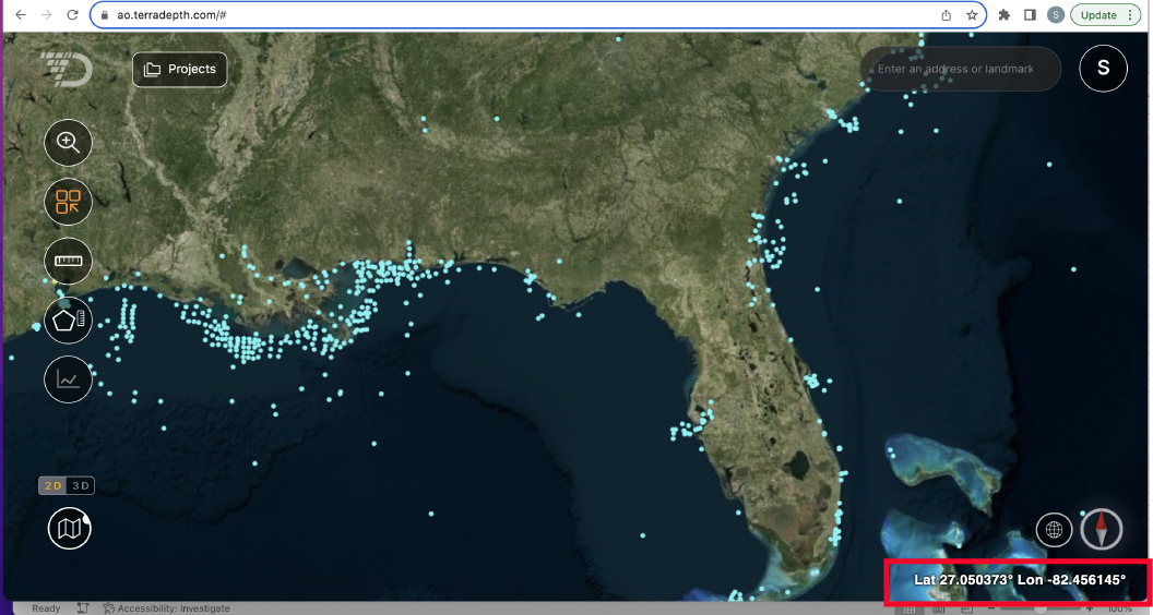
- We have increased lat/ long in the bottom right corner to 6 digits, note that while you are zoomed out, you will still see 3 digits, while the 6 digits appear as you zoom in.
Fixes:
- An issue in the API causing issues for file upload has been resolved.
August 30, 2023
Maintenance enhancements:
- We are continuously enhancing data upload and now support over 90,000 files in the same upload.
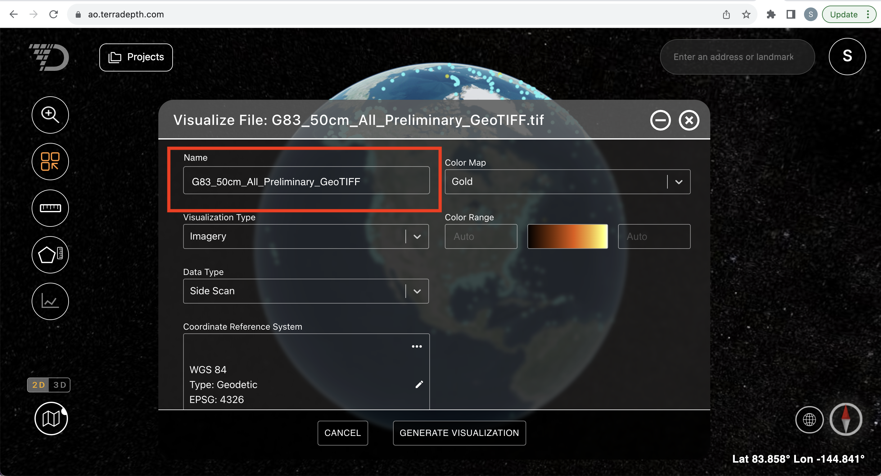
- When rendering a file, you can now rename the visualization by changing the Name from the Visualize File screen below. If a different visualization already has that same name, then you will be forced to pick a new name. Please note that certain special characters (e.g., #, +, *, &) are not allowed as part of a file name.
- We have upgraded to Cesium 1.108 which should improve performance when switching to 3D.
August 4, 2023
Enhancements:
A coordinate reference system (CRS) selector has been added to the View/ Edit Project screen and to the Visualize File screen in AO. This CRS value will be used to translate the horizontal datum from the CRS selected into WGS84 for display. Please note that the original file is not altered, only the visualized file (meaning when your customer downloads the files, they are still exactly the same as you uploaded).
In order for the elevation and profile window to display the correct values, you still need to translate the vertical component to be relative to the WGS84 ellipsoid before loading the file into AO.
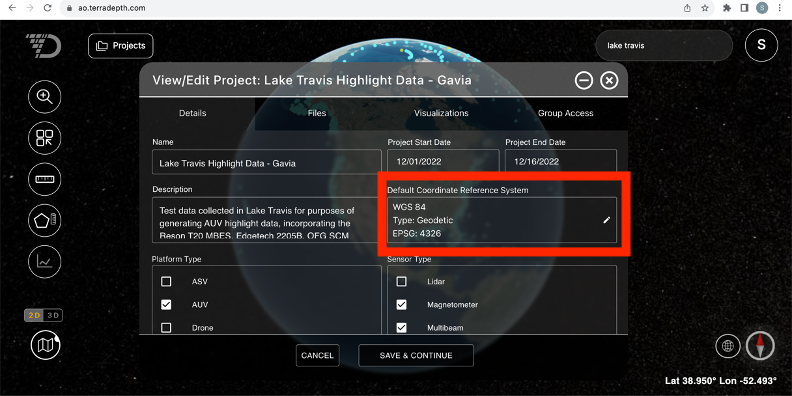
The project-level CRS will be used as default when you render a file unless AO is able to read the CRS information from the file header. Please note that the project level CRS defaults to WGS 84 for all projects but can be changed from the View/ Edit Project screen.
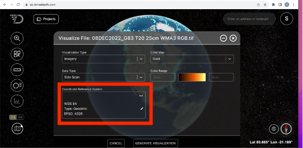
When requesting to visualize a file, the Visualize File window in AO will display:
- CRS from the file if available, OR
- Project level CRS if AO did not find a CRS in the file
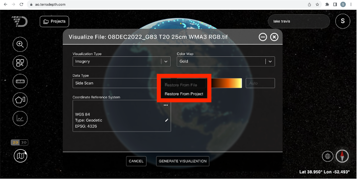
From this screen, you can go with the CRS value provided or choose to override it by clicking the pencil icon.
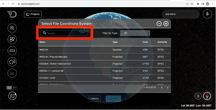
Within the Select File Coordinate System window, you can Filter by Type of coordinate system or use the Search bar to search for a term within any of the fields. Note that we are listing all EPSG codes from EPSG.org and not all of them are currently supported in AO. The ones that are not supported are disabled.
To restore CRS from the file or from the project level setting, please use the Restore From File or Restore From Project functionality on the Visualize File screen.
Note that different files within the same Project can have different CRS.
Maintenance enhancements:
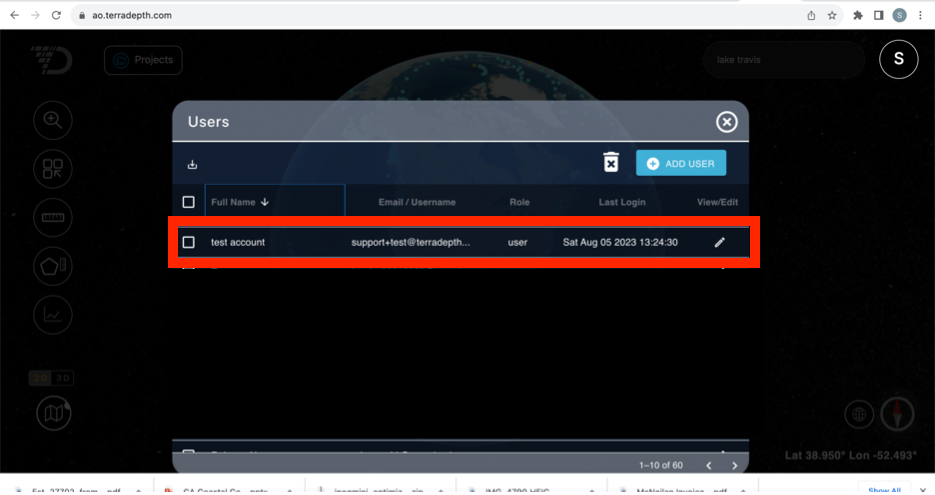
Admins and Users can now see the last login date for each AO user in their Organization from the Users list screen in AO.
Fixes:
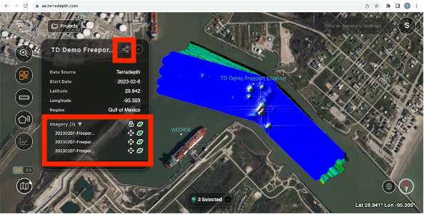
The Share View functionality now consistently preserves the imagery layer ordering in a Shared View, and the Project View Shared will be exactly the view you are looking at.
June 20, 2023
Enhancements:
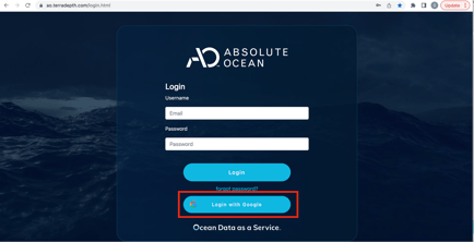
- AO now supports Single sign on as well as two factor authentication. If you are using Google as your identity provider, you can start using that today (see below). If you have other identity providers, please contact AO support.
Maintenance enhancements:
- Additional public data sets have been shared with all AO users
- You can now measure distance and area in US Survey Feet through a new user preference
- Data upload performance has been improved
- Several enhancements are made to visualization including
- Ability to visualize larger files
- Ability to visualize single-band tiff as an image
- Improved extraction of EPSG codes
- The user will now be notified of a visualization failure, in the past, the person who created the survey would receive this email
- User management enhancements
- Timeout for password reset link and new user invitations is extended to 1 day
- The email sent to new AO users has been enhanced
- Various stability and performance improvements
Fixes:
- You can now set all past start and end dates, previously, certain date selections did not work
April 12, 2023
Maintenance enhancements:
- File upload and visualization enhancements
- Enhanced file scanning on upload now provides users with better default settings during file visualization.
- ASCII files with extension *.ASC can now be visualized.
- KML/KMZ support has been expanded to display additional linked placemark icons.
- When an upload is canceled, the operation now terminates more quickly.
- New Latitude and Longitude labels in project metadata include the decimal degree abbreviation (DD) to better inform users of the expected format.
Fixes:
- Setting start and end dates in project metadata no longer allow invalid entries.
- Sensor type selections no longer reset without saving while populating project dates.
- Color ranges are now applied more consistently when visualizing with feet and meters.
- Streamlining AO user invite experience
- Users now receive an error when attempting to add an email address that is already in use.
- Newly invited users now receive an error when their invite link expires directing them to generate a new link through the reset password option on the main login.
March 22, 2023
Hello AO Users, we are excited to offer new flexibility to visualize files on the platform. Please check out the new features found in this week's release.
Maintenance enhancements:
- Allow identification of Z direction when visualizing elevation data. This allows for more flexibility and better support of data coming from third party software platforms which use the opposite of AO's Z+ up convention.
- Users may now define the min and max values for the display legend when visualizing grid and point cloud data. This allows for multiple data sets to be visualized using the same color range for seamless product review.
- Support for imagery GeoTIFFs has been expanded to include 8 and 32 bit single channel common for applications such as Hypack sidescan data.
- Users can now select the color to use when visualizing vector files like ESRI Shape and kml/kmz.
- Performance improvements have been made to support larger vector files including large numbers of overlapping point objects. These points are now clustered when viewing a large area.
- We have Improved file scanning that will automatically populate options during the visualization dialog for GeoTIFFs.
- Updated the refresh operations when making multiple area measurements to remove lingering screen text.
- Additional “.” in filenames are now supported
- Added stability for zip files when uploading and downloading
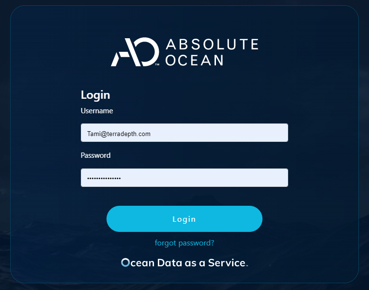
- The AO login screen has been updated to include our new Ocean Data as a Service branding.
March 9, 2023
Hello AO Users, we are doing another quick turnaround release to help bring requested functionality to our users.
Maintenance enhancements:
- Additional units are now available for viewing distances and areas in AO
- Distance: Imperial(yards and miles) and Nautical Miles
- Area: Imperial(yards and miles squared) and Nautical Miles squared
- Users can now upload large projects with thousands of files successfully.
- Multiple files with the same file name, in different directories are now recognized as unique and not duplicate when dragging and dropping the directory into the upload dialog.
- Occasionally the metadata window would not close after viewing a visualization. That issue has been addressed.
- Architecture upgrade to the latest Cesium JS
February 24, 2023
Hello AO users, we are pleased to deliver the following new enhancements because of your invaluable feedback.
Enhancements:
- Full support for uploading and visualizing Elevation data provided in US Survey Feet.
- Directly visualize ESRI Shape files to view vector geometries alongside the other AO supported data formats.
Maintenance enhancements:
- Vector point objects have a new, cleaner representation in AO.
- Better notification of the completion status of large file uploads has been provided.
- The project window can be minimized while large uploads continue, but now the project icon will flash to alert the user of the successful completion of their upload.
- A count of successful file uploads are now also provided to ensure an upload failure is not overlooked.
- Automated terrain status check and detection tools have been developed to ensure a smooth visualization experience.
- Files in different directories of a project with the same name can now be imported.
Fixes:
- Projects with only vector data present now visualize and operate more smoothly.
- Vertical exaggeration changes no longer adjust the profile window.
- Large file upload and download improvements have been made.
February 8, 2023
Enhancements:
- Users can generate a report of all files included in your Project directory or subdirectory.
Maintenance enhancements:
- Coordinate system information can now be supplied or overridden in GeoTIF and LAS/LAZ files. This allows for expanded visualization options for files without fully defined EPSG coordinate systems.
- Group names can no longer be seen by Users and Guests to aid in organization management and security.
- Enjoy a more fluid user experience with the Metadata and Project windows now movable around the AO display.
- The Project window can also be minimized during large file uploads allowing multitasking in AO.
- Imagery products can be reordered in the metadata window to aid in analysis.
Fixes:
- Users can now be re-invited to the platform if their e-mail address had been previously deleted.
- When large numbers of products were visualized, text in the Metadata window would occasionally overlap. That has been addressed.
- Improvements were made to better support the upload of large files and folders.
February 1, 2023
Maintenance enhancements:
- Horizontal coordinate system limitations have been removed for ASCII/XYZ file types. Please see the updated Supported file types and format requirements article for details on supported coordinate systems in AO.
January 18, 2023
Enhancements:
- Points (Placemarks), Lines, and Polygons are now supported for visualization in AO from KML/KMZ and GeoJSON files.
- Project files can now be uploaded in a directory structure with clickable subfolder support to provide advanced management and easy navigation within Project directories.
Maintenance enhancements:
- Survey to Project update:
- Surveys have been transitioned to Projects to better represent the expanded file management capabilities.
- The Project dialog can now be launched directly from the main AO display in the upper left hand corner. Relocation of Projects allows for better flow when interacting with tools.
- Updated main navigation menu:
- My Account: Session Settings, Profile, Password Reset, and Version information have been reorganized to provide a more intuitive user experience.
- Help Center: direct access to the AO Help Center for new Release Notes, Instructional Videos, FAQ Articles, and Support tickets.
- Contact Us: quick access link to email the AO Support Team for assistance.
- Latitude and Longitude are now optional settings during Project creation. Fields left blank on creation will be auto populated by the centroid location of the first product visualized.
Fixes:
- Upload and Download support for large numbers of files has been improved.
- Some visualized products with legend Min/Max settings displaying NaN can now be regenerated to replace the missing values.
For earlier releases, see AO Release Notes 2022.