
External layers show map data from other servers in AO, such as a provider's charts, imagery, weather or 3D tiles, without importing it. This article covers adding them to a project, the layer types AO supports, animation, and what to check when a layer doesn't load.
AO doesn't copy the data: while the layer is on, your browser loads it from the provider's server, so your network must reach that server. Inspect URL and animation also contact the provider from your AO server, so a self-hosted AO or AO OnBoard server must reach it too. See Network and firewall requirements.
Who can add external layers
Professionals and Admins add, edit and delete a project's external layers. Users see them; Guests don't see a private project's external layers. Public projects are read-only.
Add an external layer
- Open Projects at the bottom of the left toolbar, open the project, and go to its Layers tab.
- Choose + (Add external layer).
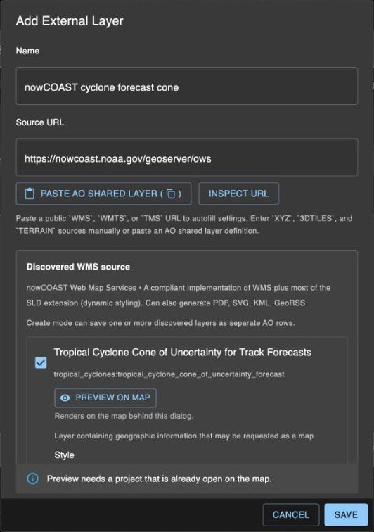
- Enter a Name and the Source URL. Or choose Paste AO shared layer to fill in the form from a layer definition copied in AO. See Sharing.
- For any type but XYZ, choose Inspect URL: AO reads the server's list of layers and sets the Layer Type. Tick one or more layers (each saves as its own layer), choose options such as Style and Time, and use Preview on map while the project is open on the map.
- Set the options below, then choose Save.
| Option | What it does |
|---|---|
| Opacity | How solid the layer is, from 0 to 100%. |
| Order (higher on top) | Where the layer draws among the project's external layers. Despite the label, lower numbers draw on top. |
| Default On | Turns the layer on when the project opens on the map. Otherwise it's listed in the Layers window, turned off. |
| Active | An inactive layer stays in the Layers tab but doesn't load on the map. |
| Show Advanced | Shows the layer's settings as text (JSON), for options the form doesn't have. |
Each name can be used once per project. To change or remove a layer later, use Edit layer or Delete layer on its row in the Layers tab.
Layer types
| Layer Type | Source URL |
|---|---|
| WMS | The service address, such as https://example.com/geoserver/wms. |
| WMTS | The service address. |
| TMS | The folder that holds tilemapresource.xml. |
| XYZ | A tile address with {z}, {x} and {y}, such as https://example.com/tiles/{z}/{x}/{y}.png. Enter it yourself: Inspect URL can't read it. |
| 3DTILES | The address of tileset.json, or its folder. |
| TERRAIN | A Cesium terrain folder (with layer.json). While on, it replaces AO's 3D base terrain; one shows at a time. |
Add WMS and WMTS layers with Inspect URL: it fills in the layer name and settings they need.
Animate a time-based layer
When a WMS or WMTS layer lists two or more times, the Animation section appears. Turn on Loop last X frames and choose 2 to 5 Frames. The Time list offers up to the 50 latest times; an animated layer always uses the latest ones.
The animation plays when you turn the layer on; Play animation and Pause animation are on its row in the Layers window. The frame's date and time show at the bottom of the map, in US Central time. For layers you add, frames change every 1.2 seconds and are at least 5 minutes apart, and while the layer is on, AO checks for newer times every 5 minutes. If your AO has the built-in Weather Radar - NOAA nowCOAST Regions layer, it changes frames every second and checks every minute.
The server must list each time as its own timestamp, such as 2026-10-01T00:00:00Z. A layer whose times are given only as a range (start/end/period) can't animate.
Layers for everyone
Terradepth support can also add a layer once for everyone in your organization, so nobody has to add it to each project. It shows in the Layers window under External Layers, with Organization as the project. On your own AO server, support can instead add it for everyone on the server: imagery then shows under Base Imagery, and 3D Tiles and terrain under External Layers with Global as the project.
To ask for one, email support@terradepth.com with your organization's name, the layer's Name and Source URL, and for a WMS or WMTS service, which of its layers you want. If you've already added the layer to a project, choose Copy shared-layer definition on it in the Layers window and paste that into the email instead.
If a layer doesn't load
| What you see | Why | What to do |
|---|---|---|
| After Inspect URL: "This server may not support cross-origin (CORS) requests from the browser" | The server may not let other websites, such as AO, load its data in your browser. | Try Preview on map. If nothing shows, ask the provider to allow CORS, or use another source. |
| Failed to inspect external layer source | Your AO server got no answer within 10 seconds, the address redirects, or it isn't a supported service. | Open the address in a browser and use the address it ends up at, such as the https:// one. |
| The layer is on, but nothing shows | The server is down or blocks other websites, the settings are wrong, or your network can't reach it. | Check that the server answers from your network. Edit the layer and run Inspect URL again. |
| External layer failed | AO couldn't set up the layer and turned it off. | Try again; then check the address and settings. |
If a Source URL points to a server on a private network, AO asks you to confirm that it's a trusted server on your internal network.
Related: Live ocean and environmental layers · Layers window · Sharing