
This article gives you a ready-made Python script that compares two grids of the same area in an AO project, such as a baseline survey and a resurvey. It's a sample you run on your own computer and can change to suit your data: AO doesn't run it. For what the results look like in AO, and how to compare surveys without code, see Run your own analysis on AO data.
The script
Download ao_change.py, or copy it from The full script at the end of this article. It needs Python 3.10 or later and four packages (pip install requests numpy rasterio scipy).
export AO_URL=https://ao.example.com
export AO_EMAIL=you@example.com
python3 ao_change.py "Kaena Point" baseline.tif resurvey.tif --mark 0.5
Run it as an Admin or a Professional, since it adds a file, a visualization and objects to the project. It asks for your AO password, then:
- Downloads both grids from the project into the folder you run it in, unless the same files are already there.
- Lines them up: it resamples the second grid onto the first grid's cells, so both have the same CRS and cell size, and leaves NoData wherever either grid has none. Give the coarser grid first: a finer second grid is averaged onto its cells.
- Makes the difference, the second grid minus the first, and saves it as
resurvey_minus_baseline.tif: a GeoTIFF with one band of Float32 values. - Adds the difference to the project and visualizes it as a Grid with a Custom Vertical Offset of 0, so its legend, the cursor's readout and profiles show the change in meters.
- With
--mark, adds a pin to the project for each area that changed by more than that many meters, at the spot that changed most, with the change as its name and Notes, CategoryChangeand Sourceao_change.py. Areas smaller than 10 cells are skipped as noise (change that with--min-cells), and it adds at most 50 pins, the largest changes first (--limit). The new pins can start hidden on the map: on the project's Objects tab, turn them on with the eye icon in the View column.
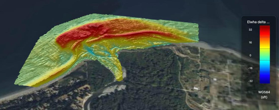
The difference between two USGS surveys of the Elwha River delta, September 2010 and July 2018, visualized as a Grid with a Custom Vertical Offset of 0, as the script does, and a Vertical Range of −10 to 10 m so no change shows green. Red is up to 10 m of new sediment. Data: U.S. Geological Survey.
Both grids need the same vertical datum and the same corrections, such as sound velocity and tide, and heights in meters: the script can't check those. With elevations (negative below the surface), a positive difference is gain, such as a mound or sediment, and a negative one is loss, such as scour.
If several projects you can see share a name, the script lists them with their ids: give the id instead of the name. If a grid's name is in several folders of the project, give its folder too, such as raw/baseline.tif. On MCP-enabled AO, you can set AO_TOKEN to an API token instead of setting AO_EMAIL (see Ways to sign in in Getting started with the AO API).
How it works
These are the calls the script makes, in case you'd like to write your own. Every call goes to https://<your AO address>/api/v1. Signing in, finding the project and moving files work as in Upload and download files with a script.
- Find the project in
GET /surveys/users/{your id}/preview. Each project has itsuuidand its organization's id,org_id. - Download both grids: list the project's files with
GET /surveys/{project uuid}/files, and fetch each withGET /file-management/geo/{fileUuid}. - Add the difference with
POST /surveys/{project uuid}/files, then send its bytes withPOST /file-management/geo/{fid}. - Visualize it as a Grid:
POST /surveys/{project uuid}/files/{fid}/render
{"params": {"name": "resurvey_minus_baseline", "org_uuid": "<org_id>",
  "epsg": "32610", "data_product_type": "model", "tileset_type": "3DTILES",
  "data_product_subtype": "jet", "vertical_epsg": null,
"custom_vertical_offset": 0, "elev_units": "m", "z_positive_down": false}}epsgis the grid's horizontal CRS, as an EPSG code. AO answers right away and visualizes the file in the background: see the project's Visualizations tab. - Add each pin, one call each, as an Admin or Professional:
POST /marker
{"name": "Change -2.49 m", "type": "Pin", "org_id": "<org_id>",
 "survey_uuid": "<project uuid>",
 "marker_coordinates": "POINT(-121.95223 36.85049)",
 "label": "Change", "comments": "-2.49 m at the most, over 190 cells: ...",
 "source": "ao_change.py"}
Good to know
- Running it again reuses the difference already in the project and doesn't visualize it twice. With
--mark, it adds the pins again. To remove pins, select them on the project's Objects tab and delete them together. - Your own analysis can replace step 3: keep the downloads and the uploads, and put your model where the script makes the difference.
- The project list includes public projects and your active organization's private projects. To work in another of your organizations' projects, switch to it in AO first.
The full script
#!/usr/bin/env python3
"""Compare two grids of the same area in an AO project: make a difference grid, add it to the
project as a grid, and optionally mark each place that changed as an object.

  python3 ao_change.py <project> <before.tif> <after.tif> [--mark METERS]

<project> is the project's name, or its id if several projects share the name. <before.tif>
and <after.tif> are the names of two GeoTIFF grids in that project, such as a baseline survey
and a resurvey. The difference is after minus before, on the before grid's cells, so give the
coarser grid first. With --mark, each area of at least 10 cells (--min-cells) that changed by
more than METERS gets a pin, one call per pin; running again adds them again.

Set AO_URL (such as https://ao.example.com) and AO_EMAIL; the script asks for your password.
On MCP-enabled AO, you can set AO_TOKEN to an API token instead.

This is a sample to adapt, not part of AO. Both grids need the same vertical datum and the same
corrections, such as sound velocity and tide, and heights in meters: the script can't check those.
Needs: pip install requests numpy rasterio scipy
"""

import argparse
import getpass
import hashlib
import json
import os
import re
import sys
from pathlib import Path

import numpy as np
import rasterio
import requests
from rasterio.warp import Resampling, reproject, transform
from scipy import ndimage

API = os.environ["AO_URL"].rstrip("/") + "/api/v1"
NODATA = -9999.0
session = requests.Session()
session.headers["User-Agent"] = "ao-change-script"
refresh_token = None


def use_tokens(response):
    """Keeps the tokens from a sign-in or renewal's user-context header."""
    global refresh_token
    response.raise_for_status()
    tokens = json.loads(response.headers["user-context"])
    session.headers["Authorization"] = "Bearer " + tokens["auth_token"]
    refresh_token = tokens["refresh_token"]


def sign_in():
    if os.environ.get("AO_TOKEN"):
        session.headers["Authorization"] = "Bearer " + os.environ["AO_TOKEN"]
        return
    email = os.environ["AO_EMAIL"]
    password = getpass.getpass(f"AO password for {email}: ")
    use_tokens(
        session.post(
            f"{API}/users/login",
            headers={"X-Email": email, "X-Password": password},
            timeout=60,
        )
    )


def sign_out():
    """Ends a password sign-in's session, so it doesn't count toward an account's 10."""
    if refresh_token:
        try:
            call("POST", "/users/logout", timeout=60)
        except requests.RequestException:
            pass


def call(method, path, upload=None, **options):
    """Calls AO. After a 401, renews the sign-in once and tries again."""
    options.setdefault("timeout", (30, 3600))
    for attempt in (1, 2):
        if upload:
            with open(upload, "rb") as f:
                response = session.request(
                    method, API + path, files={"file": (upload.name, f)}, **options
                )
        else:
            response = session.request(method, API + path, **options)
        if response.status_code == 401 and refresh_token and attempt == 1:
            use_tokens(
                session.post(
                    f"{API}/users/refresh-token",
                    headers={"X-Refresh-Token": refresh_token},
                    timeout=60,
                )
            )
            continue
        response.raise_for_status()
        return response


def find_project(name_or_id):
    """The project's record, which also holds its organization's id (org_id)."""
    me = call("GET", "/users/me").json()["items"]
    projects = call("GET", f"/surveys/users/{me['userid']}/preview").json()["items"][0][
        "surveys"
    ]
    if re.fullmatch(
        r"[0-9a-f]{8}-[0-9a-f]{4}-[0-9a-f]{4}-[0-9a-f]{4}-[0-9a-f]{12}", name_or_id
    ):
        found = [p for p in projects if p["uuid"] == name_or_id]
    else:
        found = [p for p in projects if p["name"].lower() == name_or_id.lower()]
    if len(found) != 1:
        listed = "".join(
            f"\n  {p['uuid']}  {p['name']} ({p['org_name']})" for p in found
        )
        sys.exit(
            f"{len(found)} projects match {name_or_id!r}. "
            f"Give the project's id instead.{listed}"
        )
    return found[0]


def project_files(project_id):
    rows = call("GET", f"/surveys/{project_id}/files").json()["items"][0][
        "fileStatusList"
    ]
    return [f for f in rows if not f["isVirtualDir"]]


def find_file(files, name):
    """A file by its name, or by folder/name when several folders have one."""
    found = [
        f
        for f in files
        if f["name"].lower() == name.lower()
        or ((f["filePath"] or "") + f["name"]).lower() == name.lower()
    ]
    if len(found) != 1:
        listed = "".join(f"\n  {(f['filePath'] or '') + f['name']}" for f in found)
        sys.exit(f"{len(found)} files in the project match {name!r}.{listed}")
    return found[0]


def sha256(path):
    digest = hashlib.sha256()
    with open(path, "rb") as f:
        for chunk in iter(lambda: f.read(1024 * 1024), b""):
            digest.update(chunk)
    return digest.hexdigest()


def fetch(f):
    """Downloads a project file into this folder, keeping its project folder, unless the
    same file is already here."""
    target = Path(f["filePath"] or "", f["name"])
    if not target.resolve().is_relative_to(Path.cwd().resolve()):
        sys.exit(f"{target} is outside this folder.")
    if target.exists() and sha256(target) == f["hash"]:
        return target
    target.parent.mkdir(parents=True, exist_ok=True)
    partial = target.with_name(target.name + ".part")
    with (
        call("GET", f"/file-management/geo/{f['fileUuid']}", stream=True) as response,
        open(partial, "wb") as out,
    ):
        for chunk in response.iter_content(1024 * 1024):
            out.write(chunk)
    if sha256(partial) != f["hash"]:
        partial.unlink()
        sys.exit(f"The download of {f['name']} doesn't match AO's copy: run again.")
    partial.replace(target)
    print("downloaded", target)
    return target


def difference(before_path, after_path, out_path):
    """Writes after minus before on the before grid's cells, as one band of Float32 values.
    The after grid is resampled onto those cells first, so the CRS and cell size match: averaged
    when its cells are smaller, interpolated otherwise."""
    with rasterio.open(before_path) as before, rasterio.open(after_path) as after:
        for grid in (before, after):
            if grid.crs is None:
                sys.exit(f"{grid.name} has no CRS: AO and this script need one.")
        before_values = before.read(1, masked=True).astype("float32").filled(np.nan)
        after_values = np.full(before_values.shape, np.nan, dtype="float32")
        finer = after.crs == before.crs and abs(after.res[0]) < abs(before.res[0])
        reproject(
            source=rasterio.band(after, 1),
            destination=after_values,
            src_nodata=after.nodata,
            dst_nodata=np.nan,
            dst_transform=before.transform,
            dst_crs=before.crs,
            resampling=Resampling.average if finer else Resampling.bilinear,
        )
        epsg = before.crs.to_epsg()
        if epsg is None:
            sys.exit(
                f"{before_path}'s CRS has no EPSG code, which AO needs to show it."
            )
        change = after_values - before_values  # NaN where either grid has no data
        compared = np.count_nonzero(~np.isnan(change))
        if compared == 0:
            sys.exit("The two grids don't overlap, or one of them has no data.")
        profile = {
            "driver": "GTiff",
            "height": before.height,
            "width": before.width,
            "count": 1,
            "dtype": "float32",
            "crs": before.crs,
            "transform": before.transform,
            "nodata": NODATA,
            "compress": "deflate",
        }
        with rasterio.open(out_path, "w", **profile) as out:
            out.write(np.where(np.isnan(change), NODATA, change).astype("float32"), 1)
        print(
            f"compared {compared} cells: change from {np.nanmin(change):+.2f} "
            f"to {np.nanmax(change):+.2f}"
        )
        return change, before.transform, before.crs, epsg


def upload(project_id, path):
    """Adds a file to the project. Returns its id, and whether it's new to the project."""
    record = {
        "name": path.name,
        "filePath": "",
        "hash": sha256(path),
        "on_conflict": "SKIP",
    }
    answer = call(
        "POST", f"/surveys/{project_id}/files", json={"files": {"files": [record]}}
    ).json()
    status = answer["items"][0]["fileCreationStatus"]
    if not status:
        sys.exit(
            f"A different file named {path.name} is already in the project: "
            "rename or delete it, then run again."
        )
    if status[0]["status"] == "dup":
        print(path.name, "is already in the project")
        return status[0]["fid"], False
    call("POST", f"/file-management/geo/{status[0]['fid']}", upload=path)
    print("uploaded", path.name)
    return status[0]["fid"], True


def visualize(project, file_id, epsg, name):
    """Visualizes the difference as a Grid with a custom vertical offset of 0, so the legend,
    the cursor's readout and profiles show the change itself."""
    params = {
        "name": name,
        "org_uuid": project["org_id"],
        "epsg": str(epsg),
        "data_product_type": "model",
        "tileset_type": "3DTILES",
        "data_product_subtype": "jet",
        "vertical_epsg": None,
        "custom_vertical_offset": 0,
        "elev_units": "m",
        "z_positive_down": False,
    }
    call(
        "POST",
        f"/surveys/{project['uuid']}/files/{file_id}/render",
        json={"params": params},
    )
    print(f"visualizing {name!r}: see the project's Visualizations tab")


def mark(project, change, grid_transform, crs, meters, label, limit, min_cells):
    """Adds a pin where each area that changed by more than `meters` changed the most.
    Areas of fewer than `min_cells` cells are skipped: they're usually noise."""
    areas, count = ndimage.label(
        np.nan_to_num(np.abs(change)) > meters, structure=np.ones((3, 3))
    )
    if count == 0:
        print(f"no area changed by more than {meters} m")
        return
    peaks, small = [], 0
    for index, cells in enumerate(ndimage.find_objects(areas), start=1):
        inside = areas[cells] == index
        if inside.sum() < min_cells:
            small += 1
            continue
        values = np.where(inside, change[cells], 0)
        row, col = np.unravel_index(np.argmax(np.abs(values)), values.shape)
        peaks.append(
            (
                values[row, col],
                int(inside.sum()),
                cells[0].start + row,
                cells[1].start + col,
            )
        )
    if small:
        print(f"skipped {small} areas of fewer than {min_cells} cells")
    peaks.sort(key=lambda peak: -abs(peak[0]))
    for value, cells, row, col in peaks[:limit]:
        x, y = rasterio.transform.xy(grid_transform, row, col)
        lon, lat = (v[0] for v in transform(crs, "EPSG:4326", [x], [y]))
        call(
            "POST",
            "/marker",
            json={
                "name": f"Change {value:+.2f} m",
                "type": "Pin",
                "org_id": project["org_id"],
                "survey_uuid": project["uuid"],
                "marker_coordinates": f"POINT({lon:.8f} {lat:.8f})",
                "label": "Change",
                "comments": f"{value:+.2f} m at the most, over {cells} cells: {label}",
                "source": "ao_change.py",
            },
        )
    print(f"added {min(limit, len(peaks))} objects", end="")
    print(f" (the {limit} largest of {len(peaks)} areas)" if len(peaks) > limit else "")


def main():
    parser = argparse.ArgumentParser(
        description=__doc__, formatter_class=argparse.RawDescriptionHelpFormatter
    )
    parser.add_argument("project")
    parser.add_argument("before")
    parser.add_argument("after")
    parser.add_argument(
        "--mark",
        type=float,
        metavar="METERS",
        help="add a pin for each area that changed by more than this",
    )
    parser.add_argument(
        "--limit", type=int, default=50, help="add at most this many pins (default 50)"
    )
    parser.add_argument(
        "--min-cells",
        type=int,
        default=10,
        help="skip changed areas smaller than this many cells (default 10)",
    )
    options = parser.parse_args()
    project = find_project(options.project)
    files = project_files(project["uuid"])
    before = fetch(find_file(files, options.before))
    after = fetch(find_file(files, options.after))
    out_path = Path(f"{after.stem}_minus_{before.stem}.tif")
    change, grid_transform, crs, epsg = difference(before, after, out_path)
    file_id, new = upload(project["uuid"], out_path)
    if new:
        visualize(project, file_id, epsg, out_path.stem)
    if options.mark is not None:
        mark(
            project,
            change,
            grid_transform,
            crs,
            options.mark,
            out_path.stem,
            options.limit,
            options.min_cells,
        )


if __name__ == "__main__":
    sign_in()
    try:
        main()
    finally:
        sign_out()
Related: Run your own analysis on AO data · Plan dredging from repeat surveys in AO · Upload and download files with a script · Getting started with the AO API · Connect an AI assistant to AO