Supported browsers
AO supports the last 2 versions of Google Chrome, Microsoft Edge, Safari, and Mozilla Firefox.
Can I search for Lat/ Long coordinates in AO?
Yes, you can search for Lat/ Long coordinates, type in the coordinates in the top right search bar in the following format:
xx.xxx, yy.yyy
with longitude first, then latitude. Longitude may need a minus in front.
What does the 2D & 3D toggle do?
While AO is always in 3D, the 2D/3D toggles how the globe is displayed at its surface.
2D - In 2D mode, the globe is displayed as an ellipsoid with a single global elevation of zero. Point clouds are still displayed in three dimensions in 2D. This default mode is suitable for lower bandwidth situations as AO doesn't need to be streaming in global elevation values.
3D - In 3D mode the globe is displayed with a default terrestrial digital terrain model and a default lower resolution global bathymetry dataset. Users can upload grids that will update the global terrain. Imagery in 3D is draped on default elevations and terrain can be vertically exaggerated by using the ‘V’ key.. This is also the mode required to use the profile tool.
My profile depths aren't the same as the original dataset?
Absolute Ocean is a global 3D interactive environment. To display all of your data in one map, we must choose a single common horizontal and vertical datum for the entire planet, in this case the World Geodetic System 1984 (WGS 84) ellipsoid. When visualizing your data, we create a transformed copy of your dataset on this common horizontal and vertical datum to make all the datasets line up for display in 3D. Depending on the original vertical datum, we may not be able to shift it to WGS 84 accurately.
By default we show all depths in WGS 84. You can change this to Mean Sea Level in your settings: click your profile icon in the upper right, then click My Account. In the Settings tab you can change the Elevation Datum to Mean Sea Level (MSL).
What is the default bathymetry base layer in AO?
AO's default ocean base layer is the General Bathymetric Chart of the Oceans (GEBCO) 15-arc second grid, providing depths for all of the world's oceans and a starting point for adding your custom high resolution data.
Should I use 2D or 3D to view point clouds?
Point clouds will display regardless of the terrain mode (2D or 3D).
Why aren't my point clouds visible?
When the terrain is in 3D, it may be higher in elevation than your point cloud and your point cloud will be hidden. Switching the terrain to 2D mode usually solves this problem.
How do I use the profile tool in Absolute Ocean?
The terrain must be in 3D mode to use the profile tool in AO.
What analysis tools are available in Absolute Ocean?
In AO you can measure distance, area and profiles. View our Tools video here.
How do I quickly open multiple projects in Absolute Ocean?
To quickly open multiple projects in AO, hold down the SHIFT key and draw a rectangle over multiple project dots in AO. This is a shortcut to turn on the Multi-Select tool that looks like this:

What kind of files can I upload into Absolute Ocean?
You may upload any files you like into AO, however only certain file types may be visualized and must be specifically formatted. To see file types supported for visualization and their strict formatting requirements, please see this article.
Where do my files live in Absolute Ocean?
All of your files in AO live within a project.
How do I upload files to Absolute Ocean?
To upload files into AO, go to Projects | Add Project | Files | Upload File.
How do I download files from Absolute Ocean?
To download files from AO, go to Projects | Inspect Project | Files | Select Files | Download.
How do I know what type of user I am (Admin, Users or Guest)?
Click on your first initial in the upper right-hand corner and select My Account. Click on Profile | Your role will be displayed.
How long do password reset links work?
Password reset links expire after one hour.
If I'm a User or a Viewer (Guest), how do I change my account to become an administrator?
Contact your organization's administrator and request a change. They can change your role from the User's menu. See the documentation here.
How do I see the status of Absolute Ocean?
To view the status of AO, use this link: https://status.ao.terradepth.com/
How do I make an enhancement request?
Please use the form in the lower right of this page, or the Help Center link in Absolute Ocean, to submit an Enhancement Request.
How can I share a view within Absolute Ocean?
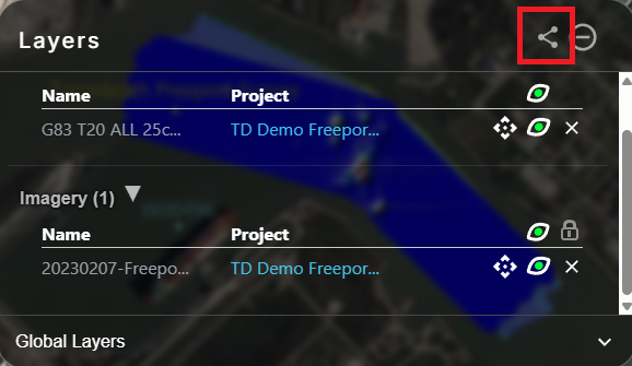
To share a view, click the share icon in the Layers window. This will copy a link to your clipboard. You can then share this link with a colleague. Your colleague must have an AO account in the same organization and access to the project that you're sharing.