
The map tools find places, measure distances, areas and profiles, compare layers and export what you see. Distances, areas, heights and positions follow your display settings: see My Account and display settings.
Left toolbar
| Tool | What it does |
|---|---|
 Zoom To Area |
Drag a rectangle; the map flies to it and the tool turns off. |
 Multiple Projects - OR Hold Shift and Drag Rectangle |
Drag a rectangle over project dots to open every project inside it. Or hold Shift and drag, without choosing the tool. |
 Measure Distance |
Measures a line of one or more segments. |
 Measure Area |
Measures the area of a shape you draw. |
 Measure 3D Profile |
Charts elevation along a line. Needs 3D terrain. |
 Swipe Tool |
Compares one layer with the others using a slider. |
One tool is on at a time. To turn a tool off and clear what it drew, choose it again or press Esc. Esc doesn't close the Swipe Tool, and it stays open while you use the others, such as a profile.
Measure Distance and Measure Area
Choose the tool, then click to place points. Right-click to finish:
- Measure Distance labels each segment and shows the Segment and Total at the cursor. Right-click clears the line so you can start again. Distances are horizontal, along the earth's surface.
- Measure Area needs at least three points. Right-click closes the shape and shows its horizontal area in the middle. Your next click starts a new shape.
Measure 3D Profile
With 2D terrain the button is gray (Measure 3D Profile - Requires 3D Terrain): switch Base Terrain to 3D first (see Terrain and imagery, below).
- Choose Measure 3D Profile.
- Click the start point, then the end point.
The Surface Profile window charts elevation along the line, with a line for Base Terrain and one for each grid or other 3D layer it crosses, plus the line's Distance and Slope. Turn GridLines, Key and Base Terrain on or off, or click a layer in the key to hide its line; with Base Terrain off, small height changes fill the chart. Where the line leaves a grid or crosses a gap in it, that grid's line drops to the base terrain. The info icon shows the datum the heights use (WGS84 or MSL). Export As... downloads the chart as a PNG or JPG image.
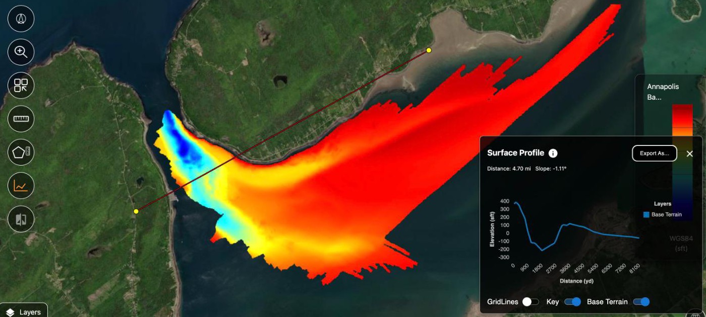
Click the map again for a new profile. Close it with X or Esc.
Swipe Tool
The Swipe Tool needs at least two layers on the map; until then its tooltip reads Swipe Tool - Please select two or more layers.
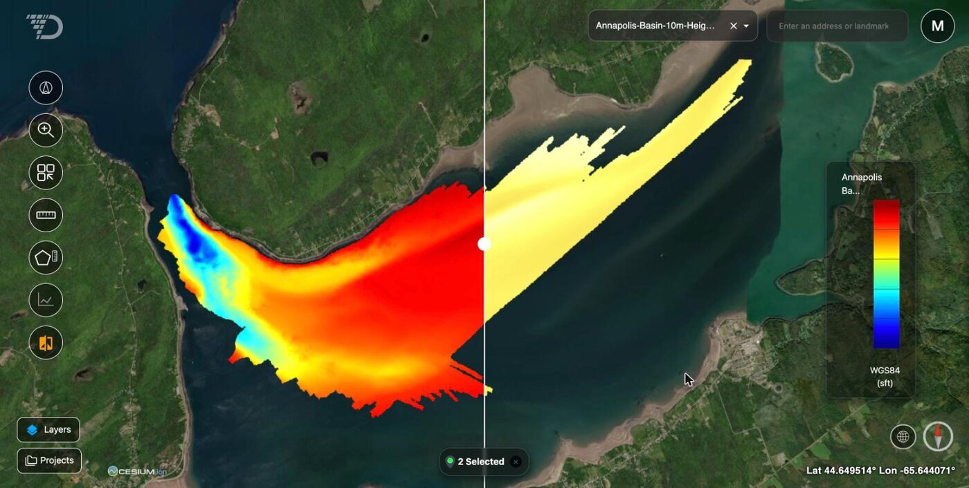
- Choose Swipe Tool. A layer box opens beside the search box.
- Choose the layer to compare. It shows right of the slider; your other visible layers show left of it.
- Drag the white slider across the map.
Choose Swipe Tool again to close it. While it's open, you can't reorder imagery in the Layers window.
Compare two surveys of the same area
Show only the two surveys, then choose the Swipe Tool and drag the slider to see where they differ. With Base Terrain set to 3D, draw a Measure 3D Profile line across that spot, inside the data: the chart draws one line per survey, and stays open while you swipe. Turn off the profile's Base Terrain line so small differences stand out. To measure the change everywhere, see Run your own analysis on AO data.
Right-click menu
Right-click the map when Measure Distance and Measure Area are off:
| Item | What it does |
|---|---|
| Measure Distance | Turns on Measure Distance. |
| Export GeoTIFF | Saves an image of an area as a GeoTIFF file. |
| Add Object | Adds an object where you clicked (Professional and Admin). See Objects. |
| Copy Lat/Lon to Clipboard | Copies the clicked position, in your position format. |
Export GeoTIFF
- Right-click the map and choose Export GeoTIFF.
- In the GeoTIFF Export panel, choose Select Region, then drag over the area: at most 10 km in any direction.
- Choose Export GeoTIFF.
AO briefly switches to a flat view, captures the area and downloads ao-export-<date and time>.tif. The file is a georeferenced color image of the top imagery, vector and grid layers there, without labels or markers. It holds colors, not data values.
Search for a place or coordinates
Type in the search box at the top of the map and choose a suggestion, or press Enter. AO flies there.
With AO's own search, you can also type coordinates, latitude first:
| Format | Examples |
|---|---|
| Decimal degrees (DD) | 41.403367, 2.174017 · -33.8688 151.2093 · 33.8688 S, 151.2093 E |
| Degrees and minutes (DM) | 41° 24.202′ N, 2° 10.441′ E |
| Degrees, minutes and seconds (DMS) | 40° 41′ 21″ N, 74° 2′ 40″ W |
Use S and W, or a minus sign, for south and west. Separate the two values with a comma, a semicolon or |. Decimal degrees, and values with N, S, E or W, can also be separated by a space. If a value is out of range, AO shows Invalid coordinates. Enter latitude, longitude in DD, DM, or DMS format. AO always uses its own search when it has no internet access.
Terrain and imagery
In Layers (bottom of the left toolbar), Global Layers has:
- Base Terrain: 2D (flat, the default) or 3D. Switching to 2D closes an open profile.
- Contour Lines: lines every 100 m of elevation, on 3D terrain only, once you zoom in below about 100 km.
- Base Imagery: Aerial (the default), Aerial+Labels, Roads+Labels and NOAA Charts, plus any added for everyone on your AO.
More in Layers window and Hotkeys available in AO.
Around the map
| Control or readout | What it does |
|---|---|
| Orient North (compass, bottom right) | Turns the map north-up, looking straight down, and zooms out a little. |
| World View (globe icon, bottom right) | Zooms out to the whole Earth. |
| Cursor position (bottom right) | Lat and Lon under the cursor, in your position format. With 3D terrain, or over a layer, also Elev (WGS84) or Elev (MSL), in your elevation units. |
| Camera Height (top right) | Press E to show or hide it. Always in meters. |
| Selected (bottom of the map) | How many layers and objects are on the map. Its X clears them from the map. |
Availability: Export GeoTIFF and AO's own search are turned on per organization. To use them, contact support@terradepth.com.
Related: Layers window · HotKeys available in AO · Reports and exports